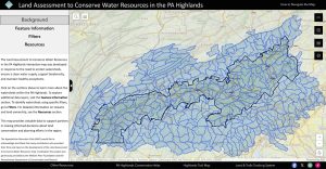
 The Land Assessment to Conserve Water Resources in the Pennsylvania Highlands project is live! This project focuses on providing key resource information to protect a watershed’s ability to produce clean water by incorporating findings from the National Forests to Faucets 2.0 (F2F2) project, conducted by the USDA Forest Service (USFS), the Open Space Institute (OSI), and the Lancaster Conservancy. The goal is to support our partners in protecting forests to improve water quality through watershed analysis. In addition, environmental risk factors and other relevant data are included in an interactive online map. This map serves as a decision support tool, helping organizations enhance their conservation efforts.
Protecting watersheds is essential for ensuring a clean water supply, supporting biodiversity, and maintaining healthy ecosystems. Protecting forests and riparian forest areas within a watershed is vital, as they act as natural filters, regulate water flow, prevent erosion, and maintain water quality by trapping sediment and pollutants. These actions ultimately ensure a healthier and more reliable surface water source for downstream communities. Additionally, these areas provide critical habitats for wildlife and help mitigate climate change by storing carbon. Healthy forests are key to sustaining clean, reliable water resources and ecosystem stability within watersheds.
We hope that this map can serve as a tool, promoting healthy forests and watersheds for land and water conservation organizations within the region. To read the report click here and to access the map, click here.