News
For events, opportunities, and information about the Pennsylvania Highlands Trail, please click the link below to see the PDF version of the PA Highlands Trail June 2026 Newsletter. June 2026 PA Highlands Newsletter
May 29, 2026
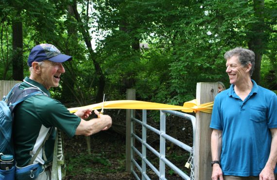
This past Wednesday, the Appalachian Mountain Club and Bridgeton Township held a ribbon cutting to officially open the Bridgeton Nature Preserve Trail. This two-mile loop is an offshoot of the PA Highlands Trail Network and was built by the PA Highlands Trail Stewards, a group of AMC Delaware Valley Chapter volunteers led by Greg Bernet. At the event, township supervisor Gard Holby, Greg Bernet, Jim Engel, and Eric Anderson shared a few words about the trail acquisition and building process before cutting the ribbon to open the new trail. Afterwards, a hike was lead on the trail for ceremony attendees. Thank you to all who supported the development of the Bridgeton Nature Preserve Trail, and if you haven’t hiked it yet, check it out!
For events, opportunities, and information about the Pennsylvania Highlands Trail, please click the link below to see the PDF version of the PA Highlands Trail May 2026 Newsletter. May 2026 PA Highlands Newsletter
April 29, 2026
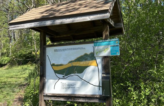
This week, the Appalachian Mountain Club and the Horse-Shoe Trail Conservancy installed four new interpretive signs at trail kiosks in Berks, Lancaster, and Lebanon counties. These signs include a map of the Pennsylvania Highlands Trail Network as well as information about the two co-aligned trails. The signage can be found at the following locations: The French Creek Hopewell Big Woods Trail Parking Lot The Horse-Shoe Trail Access Point at the Brecknock Township Municipal Building The Horse-Shoe Trail Parking Lot on Furnace Hills Pike The Governor Dick Park Parking Area on Rte. 72 The installation of these signs comes after the completion of marking all road crossings for the PA Highlands Trail along the Horse-Shoe Trail, an exciting accomplishment that brings the PA Highlands Trail one step closer to being fully blazed! Next time you’re out on the 61 miles of the Horse-Shoe Trail that co-align with the PA Highlands Trail, be sure to look for these new signs and for a PA Highlands blaze.
For events, opportunities, and information about the Pennsylvania Highlands Trail, please click the link below to see the PDF version of the PA Highlands Trail April 2026 Newsletter. April 2026 PA Highlands Newsletter
For events, opportunities, and information about the Pennsylvania Highlands Trail, please click the link below to see the PDF version of the PA Highlands Trail March 2026 Newsletter. March 2026 PA Highlands Newsletter
For events, opportunities, and information about the Pennsylvania Highlands Trail, please click the link below to see the PDF version of the PA Highlands Trail February 2026 Newsletter. February 2026 Newsletter
For events, opportunities, and information about the Pennsylvania Highlands Trail, please click the link below to see the PDF version of the PA Highlands Trail January 2026 Newsletter. January 2026 Newsletter
For events, opportunities, and information about the Pennsylvania Highlands Trail, please click the link below to see the PDF version of the PA Highlands Trail November 2025 Newsletter. PA Highlands Newsletter November 2025
November 21, 2025
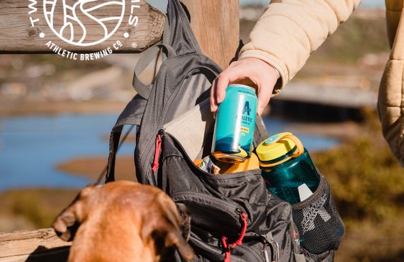
Cheers to Athletic Brewing Company for funding our work! We’re honored to be part of their Two For The Trails program – an initiative that donates up to $2 million annually to help protect, preserve, and maintain local trails and outdoor spaces. This grant will help us rehabilitate the Brickyard Pond Trailhead on Heller Road in Richland Township, a popular fishing spot and Pennsylvania Highlands Trail access point. Keep an eye out for exciting volunteer opportunities relating to this project in the early spring! The Appalachian Mountain Club looks forward to collaborating with Richland Township.
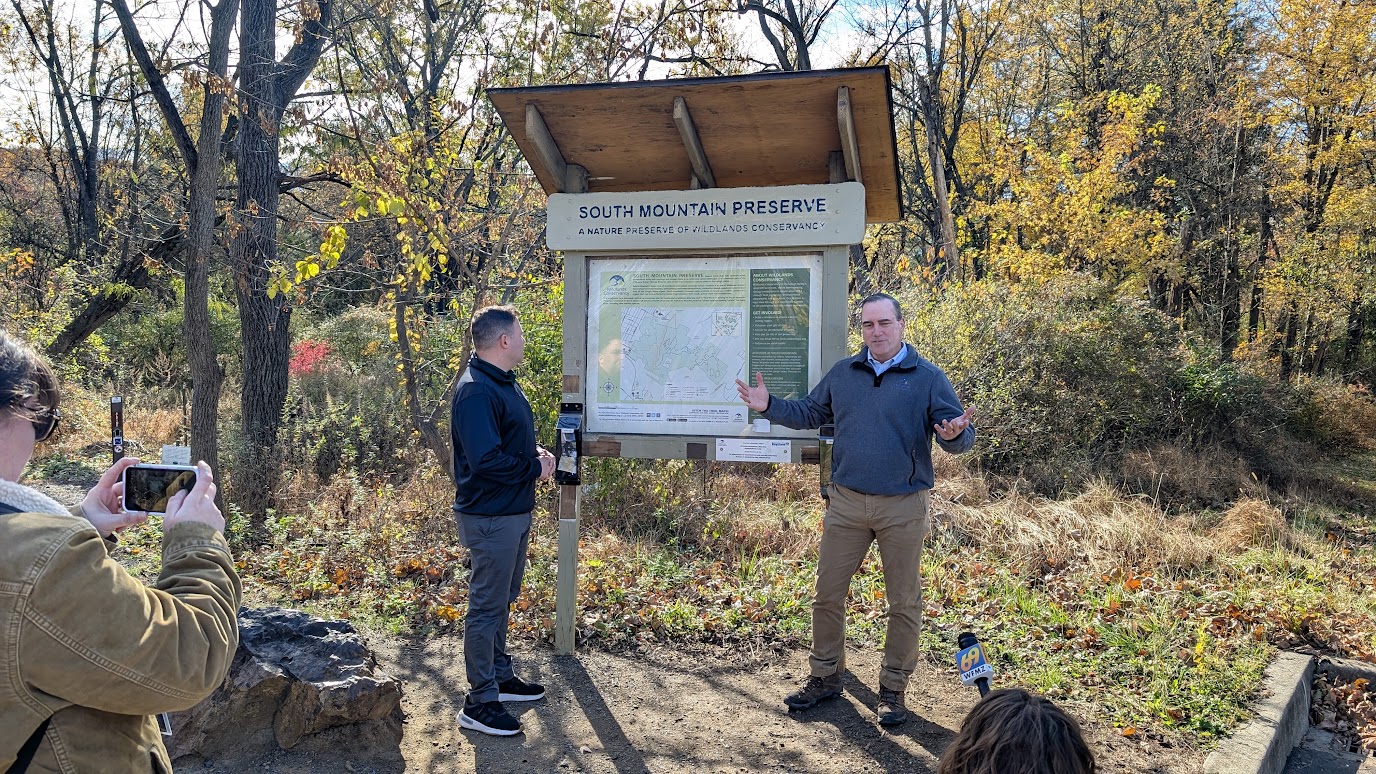
Earlier this month, Congressman Ryan Mackenzie joined non-profit partners from the Appalachian Mountain Club, Wildlands Conservancy, and the Delaware and Lehigh Nation Heritage Corridor at Wildlands Conservancy’s South Mountain Preserve. The group hiked throughout the property to share their work on conservation in the Lehigh Valley. The Land and Water Conservation Fund (LWCF) was of special note as funding from that grant program was used to purchase Allentown’s Reservoir Park, which borders South Mountain, and collectively the two properties make the 750-acre Robert Rodale Preserve. LWCF funding has also been used throughout the Lehigh Valley to protect parts of the Pennsylvania Highland’s, through the Highlands Conservation Act grant program, within LWCF. The Highlands is a unique region, through four states, that provides drinking water to a large portion of the mid-Atlantic region. It is also a crucial wildlife habitat and recreation area that has gained increased federal recognition since 2004. Despite permanent authorization in 2020 through the Great American Outdoors Act, LWCF has faced recent threats from Washington. Due to these threats, there have been risks to projects that are currenting in progress or development. Representative Mackenzie has been a vocal supporter of protecting LWCF and ensuring that these important conservation tools stay intact not just for the Highlands region but for the entire country. This visit served not only as a time to thank Representative Mackenzie for the work that he is doing to protect the Highlands but to also show him parts of the landscape that has been preserved through federal programs. With the work of non-profits and support Representatives, LWCF will still be a critical funding source used to protect the nation’s land and water for generations to come.
For events, opportunities, and information about the Pennsylvania Highlands Trail, please click the link below to see the PDF version of the PA Highlands Trail October 2025 Newsletter. Pennsylvania Highlands Trail Network October 2025 Newsletter